 eAtlas Data Catalogue
Great Barrier Reef
Type of resources
Available actions
Topics
Keywords
Contact for the resource
Provided by
Formats
Representation types
Update frequencies
status
-

This dataset contains data on carbon chemistry on inshore reefs of the Great Barrier Reef (GBR). Main parameters measured were temperature, total alkalinity and dissolved inorganic carbon. The data was collected six times over two years (September 2011 - June 2012) covering a comprehensive latitudinal range. The aim of this study was to investigate carbon chemistry on inshore reefs, and compare it to offshore reefs and historical data. Research to date on reef calcification and inorganic carbon dynamics within the GBR system has largely focused upon on-reef processes on mid- and outer-shelf reefs. Relatively little work has been done on the shelf-scale dynamics of inorganic carbon in the GBR system and almost no consideration has been given to the many inshore reefs close to the coast that are under the greatest threat from increases in runoff of sediment, nutrients and pesticides. The ratio of primary productivity and respiration (P/R) of inshore reefs are often lower than on reefs further from the coast due to decreased light availability associated with greater turbidity inshore. Because of this, inshore reefs may be less able to buffer rising dissolved inorganic carbon (DIC) by photosynthesis. Method: Water sampling for inshore chemical characteristics was carried out at 14 nearshore fringing reefs at islands between 16 and 23° S. Twelve of the 14 core sites are within 15 km of the mainland and all are directly affected on a seasonal or episodic basis by terrestrial runoff. Sampling at the inshore core reef sites (Visits, n = 6) was conducted at four-monthly intervals over two years (September 2011–June 2013) in the late dry season (September–October), wet season (February) and early dry season (June). The GBR region has a monsoonal climate with most (ca. 60–80%) rainfall falling in the January to March period. All samples were collected during the day time. Water samples for analysis of Total Alkalinity (TA) and Dissolved Inorganic Carbon (DIC) were collected at the 14 core reefs. At each of the inshore locations, surface (~1 m water depth) and near-bottom (average depth 9.4 m, 1 SD = 3.1 m) water samples were collected from the R/V Cape Ferguson using 10 L Niskin bottles. These open water stations were 0.3–2 km from the neighbouring reef. In addition, divers collected water near-bottom (average depth 6.5 m) on the reef slopes of the coral reef at each inshore site. Duplicate aliquots (250 ml) were carefully drawn from the Niskin bottles for TA and DIC analysis, taking care to avoid bubble formation and minimize headspace. Samples were fixed with 125 µl of saturated HgCl2. Samples for TA and DIC were analysed using a VINDTA 3C titrator (Marianda, Germany) at the Australian Institute of Marine Science (AIMS). Alkalinity was determined by acid titration and DIC by acidification and coulometric detection (UIC 5105 Coulometer) of the evolved CO2. The VINDTA titrator was calibrated with Certified Reference seawaters (A. G. Dickson, Scripps Institute of Oceanography, Dixon, Batch 106). Further details can be found in this publication: Uthicke S, Furnas M, Lønborg C (2014) Coral Reefs on the Edge? Carbon Chemistry on Inshore Reefs of the Great Barrier Reef. PLoS ONE 9(10): e109092. doi: 10.1371/journal.pone.0109092 Limitations: Data are limited to GBR inshore reefs. Format: The data is text in csv format, Uthicke et al NERP 5_2 carbon chemistry data.csv Data Dictionary: - Station: a unique station code from the AIMS database - Island: sample location - Code: a depth related code - Depth (in m): actual sampling depth, 0m=surface sample, assumed to be on average from 1m depth - Dupl.: duplicate number - Temp.: temperature (°C) - Sal.: salinity - DIC: dissolved inorganic carbon (µmol kg-1) - TA: Total Alkalinity (µmol kg-1) - Date: collection date - S_Cl: - pH: calculated pH on total scale - pCO2: calculated partial pressure of CO2 (µatm) - ?ar : saturation state of aragonite - Time: time of sample collection.
-
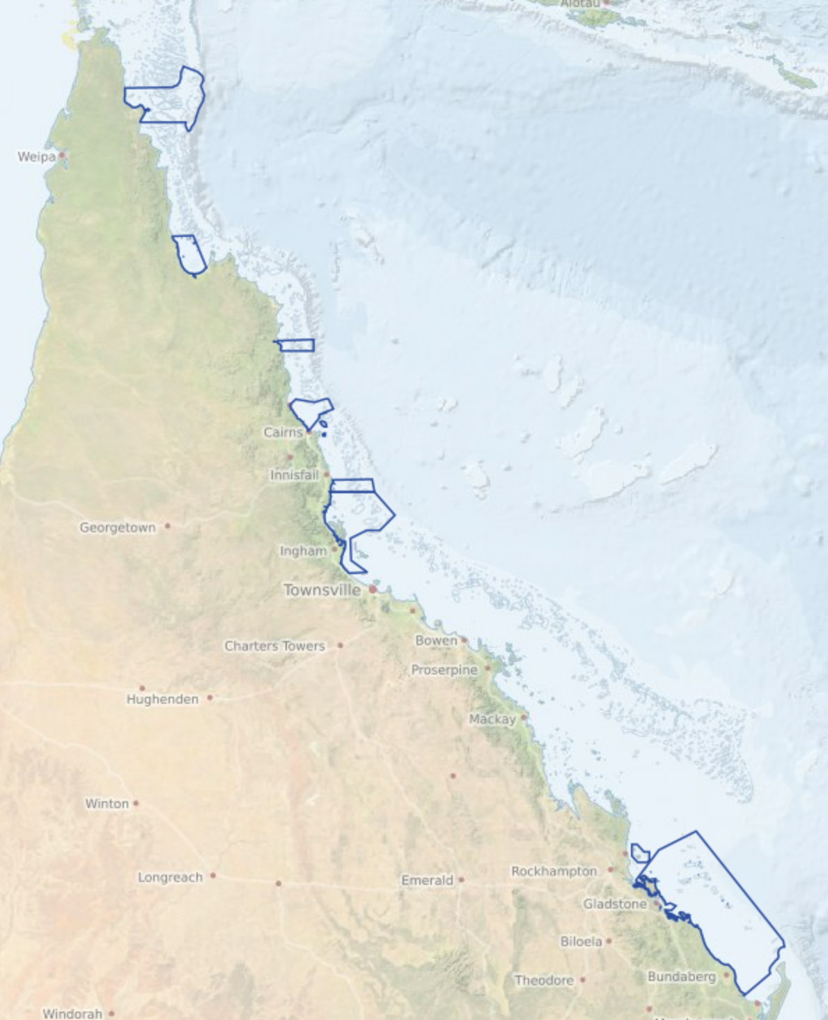
Traditional use activities in the Great Barrier Reef Marine Park are managed under the Great Barrier Reef Marine Park Act 1975, and the Great Barrier Reef Marine Park Regulations 2019. The Great Barrier Reef Marine Park Zoning Plan 2003 recognises that under section 211 of the Native Title Act 1993, native title holders may undertake traditional use of marine resources in the Great Barrier Reef Marine Park. eAtlas Notes: This is not the authoritative metadata for this dataset. The authoritative source is available from the GBRMPA data portal https://geoportal.gbrmpa.gov.au/datasets/GBRMPA::gbrmpa-traditional-use-of-marine-resources-agreement-tumra-areas. This metadata is retained in the eAtlas to include any additional notes and description about the dataset. Traditional Use of Marine Resources Agreements are community-based plans for management of traditional resources which are accredited in legislation and have proved a successful mechanism for joint management of the Reef. Traditional Use of Marine Resources Agreements describe how Great Barrier Reef Traditional Owner groups work in partnership with the Australian and Queensland governments to manage traditional use activities on their Sea Country. Each Traditional Use of Marine Resources Agreements has a committee to manage the agreement and traditional use of marine resources in their Sea Country, including traditional take, if any of important species such as dugongs and turtles. Their management of traditional use is based on both cultural lore and contemporary science and are also used for broader Sea Country planning and management. Description of the data: The following are the list of TUMRAs included in this dataset: - Dharumbal Region Woppaburra Section: Offshore area including the Keppel Islands Group and the surrounding waters. - Girringun: Offshore area between Rollingstone and Mission Beach, including Hinchinbrook and Dunk Islands, but excluding the Palm Island Group. - Wuthathi: Offshore area between Captain Billy Landing and the mouth of the Olive River, extending east past Raine Island. - Port Curtis Coral Coast: Extending from the entrance of Port Alma south to Burrum Heads, including Curtis Island and the Capricorn and Bunker Island groups. - Yuku Baja-Muliku: Monkhouse Point south to Forsberg Point and extending east to just past the Ribbon Reefs. - Lama Lama: Near Massy Creek, east to Hedge Reef and south through Princess Charlotte Bay to the Normanby River in the south. - Yirrganydji: Area between Port Douglas and Cairns, extending east past Spur, Onyx, Nicholas and Hope Reefs. - Gunggandji: Green Island, Michaelmas Cay, Fitzroy Island, and the surrounding waters. - Mandubarra: Offshore areas between the mouth of Mourilyan Harbour south to Kurrimine Beach, extending east past Armistice Reef. Change Log: 2023-07-24 Dataset setup in eAtlas based on most recent available version of data from 2020-03-11